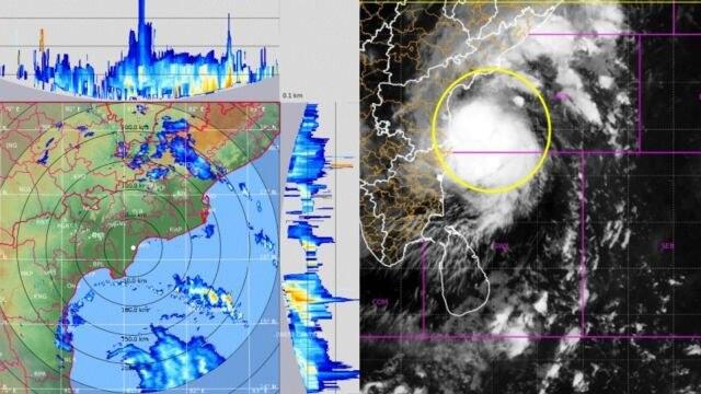
The Department of Meteorology has told fishing and naval crews to stay out of several deep-sea areas after Cyclonic Storm Murasu intensified into a Severe Cyclonic Storm on Monday.
The department said the storm was near latitude 14.1°N and longitude 81.4°E at 8.30 a.m. on Monday, over the west-central and adjoining southwest Bay of Bengal.
It is very likely to move northwestwards and cross the south Andhra Pradesh coast in India between midnight on Monday and the early hours of Tuesday, the department said.
Fishing and naval communities have been advised to avoid the deep-sea areas between 10°N and 17°N and between 80°E and 85°E until further notice. Those already in these areas have been urged to move to safer locations.
A separate warning covers the deep-sea areas stretching from Mannar to Trincomalee via Kankesanthurai.
Background
Sri Lanka’s second inter-monsoon period, from October to November, is a time when low-pressure systems and cyclones commonly form in the Bay of Bengal. The Department of Meteorology issues warnings for the seas around the island whenever such a system is close enough to affect them.
Even when a storm crosses the coast of another country, as Murasu is expected to cross India’s, it can still disturb the sea and weather around Sri Lanka. That is why the department advises crews to stay out of the water well before a storm makes landfall.
For sea areas around the island, the department expects showers or thundershowers at several places. South-westerly or southerly winds of 25 to 35 kmph are forecast.
Winds could rise to 40 to 45 kmph in the sea areas from Chilaw to Trincomalee via Mannar and Kankesanthurai. These areas could be fairly rough at times, while other sea areas around the island are expected to stay moderate.
During thundershowers, the department said, temporarily strong gusty winds of 60 to 70 kmph and very rough seas could occur.
What it means
The warnings matter most for fishing crews and Navy personnel working in the northern, north-western and eastern seas, and for the families who depend on their catch. The department has urged them to remain alert to further forecasts and warnings.
Boat owners and crews can follow updates from the Department of Meteorology, which revises its notices as the storm moves. The advice to avoid the named sea areas applies until further notice, so crews should check for new bulletins before putting to sea.
The department’s notices cover the sea areas only. Readers on land can expect showers in places, but the department’s warning does not describe a threat to inland areas.